檔案:View from connors hill panorama.jpg

Yi-lám thai séu: 800 × 199 chhiong-su. Khì-thâ kié-sak-thu: 320 × 80 chhiong-su | 640 × 159 chhiong-su | 1,024 × 255 chhiong-su | 1,280 × 318 chhiong-su | 4,289 × 1,067 chhiong-su.
Ngièn-pún tóng-on (4,289 × 1,067 chhiong-su, vùn-khien thai-séu: 1.14 MB, MIME lui-hîn: image/jpeg)
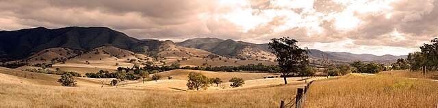
This image was selected as picture of the day on Wikimedia Commons for 15 March 2009. It was captioned as follows: English: View from Connors Hill in East Gippsland Shire, Victoria, Australia. Other languages:
Afrikaans: Uitsig vanaf Connorsheuwel in die Oos-Gippslanddistrik van die Australiese deelstaat Victoria Bosanski: Pogled sa Connors Hill-a u Istočnom Gippsland Shire-u u Viktoriji u Australiji. Dansk: Udsigt fra Connors Hill i East Gippsland Shire, Victoria, Australien. Deutsch: Blick vom Connor-Hügel im lokalen Verwaltungsgebiet East Gippsland Shire im australischen Bundesstaat Victoria English: View from Connors Hill in East Gippsland Shire, Victoria, Australia. Español: Vista desde Connors Hill en East Gippsland Shire, Victoria, Australia. Esperanto: rigardo de la moneteto Connors Hill al pejzaĝo en la adminstra regiono East Gippsland Shire en Viktorio, Aŭstralio. Íslenska: Útsýni frá Connors Hill í East Gippsland Shire, Viktoríufylki, Ástralíu. Magyar: Kilátás a Connors Hillről (Ausztrália, Victora, East Gippsland Shire) Português: Vista a partir de Connors Hill, em East Gippsland Shire, Victoria, Austrália Suomi: Näkymä Connors Hillistä, East Gippsland Shirestä, Victoriasta, Australiasta. Winaray: An lantaw tikang ha Connors Hill ha East Gippsland Shire, Victoria, Australia. 한국어: 오스트레일리아의 빅토리아 주에 있는 에스트 깁슬랜드 샤이어의 코너스 힐. 中文: 澳大利亚东吉普斯兰郡康纳斯山风景 中文(繁體): 澳洲東吉普斯蘭郡康納斯山風景 |
This image was selected as picture of the day on Vietnamese Wikipedia.
|
|

| Mèu-sut |
Français : Vue de Connors Hill dans le comté du Gippsland oriental, État de Victoria, Australie. |
| Lòi-ngièn | Chhṳ-kâ ke chok-phín |
| Chok-chá | User:Fir0002 |
| 拍攝地點 | | 位於此地的本圖片與其他圖片: OpenStreetMap |
|---|
|


| ||||||||


|
已授權您依據自由軟體基金會發行的無固定段落、封面文字和封底文字GNU自由文件授權條款1.2版(不含其他版本),對本檔進行複製、傳播和/或修改。該協議的副本列在GNU自由文件授權條款中。 | 僅1.2版 |
本文件根據以下許可發布:
Attribution NonCommercial Unported 3.0 |
Vùn-khien li̍t-sṳ́
Tiám-khim ngit-khì / sṳ̀-kiên lòi chhà-khon tông-sṳ̀ chhut-hien-ko ke vùn-khien.
| Ngit khì / Sṳ̀-kiên | Suk-lio̍k-thù | Vì-thu | Yung-fu | Yi-kien | |
|---|---|---|---|---|---|
| tông-chhièn | 2012年10月28日 (Ngit) 22:22 | 4,289 × 1,067(1.14 MB) | Fir0002 | Reverted to version as of 02:15, 11 January 2006 | |
| 2011年9月3日 (Liuk) 06:44 | 4,289 × 1,067(1.24 MB) | 1970gemini | Quality-Update | ||
| 2006年1月11日 (Sâm) 02:15 | 4,289 × 1,067(1.14 MB) | Fir0002 | View from Connors Hill {{Fir0002 20D}} |
Vùn-khien yung-chhú
Hâ poi ke 1-chak ya̍p-mien lièn-chiap to pún vùn-khien:
Chhiòn-vet tóng-on sṳ́-yung chhong-khóng
Hâ-lie̍t khì-thâ Wiki chûng sṳ́-yung liá-chak tóng on:
- ar.wikipedia.org ke sṳ́-yung chhong-khóng
- awa.wikipedia.org ke sṳ́-yung chhong-khóng
- azb.wikipedia.org ke sṳ́-yung chhong-khóng
- az.wikipedia.org ke sṳ́-yung chhong-khóng
- bn.wikipedia.org ke sṳ́-yung chhong-khóng
- br.wikipedia.org ke sṳ́-yung chhong-khóng
- crh.wikipedia.org ke sṳ́-yung chhong-khóng
- cs.wikipedia.org ke sṳ́-yung chhong-khóng
- cv.wikipedia.org ke sṳ́-yung chhong-khóng
- de.wikipedia.org ke sṳ́-yung chhong-khóng
- en.wikipedia.org ke sṳ́-yung chhong-khóng
- Shire of East Gippsland
- User:Fir0002/Fir0002 gallery/Featured Pictures
- Portal:Australia
- Wikipedia:Featured pictures thumbs/02
- User talk:Fir0002/Archive 2
- User:Fir0002/Fir0002 gallery/20D/Scenery
- User:Wikisoft*
- User:Cyde/Featured pictures
- Wikipedia:Featured picture candidates/Image:View from connors hill panorama.jpg
- Wikipedia:Picture of the day/May 2006
- Wikipedia:Featured picture candidates/February-2006
- Wikipedia:Wikipedia Signpost/2006-02-13/Features and admins
- Wikipedia:Featured picture candidates/Eastrock02
- Wikipedia:Picture of the day/May 26, 2006
- Wikipedia:Featured picture candidates/April-2006
- Wikipedia:POTD/May 26, 2006
- Wikipedia:POTD column/May 26, 2006
- Wikipedia:POTD row/May 26, 2006
- User:Fir0002/Fir0002 gallery/canon
- Wikipedia:Featured pictures/Places/Panorama
- User:Emil76~enwiki/Panorama
- User:Passargea/Favourite pictures/Nature
- User:HueSatLum/Testing/Images
- Wikipedia:Wikipedia Signpost/Single/2006-02-13
- eo.wikipedia.org ke sṳ́-yung chhong-khóng
- es.wikipedia.org ke sṳ́-yung chhong-khóng
- fi.wikipedia.org ke sṳ́-yung chhong-khóng
- fr.wikipedia.org ke sṳ́-yung chhong-khóng
Kiám-sṳ liá vùn-khien ke kiên-tô chhiòn-vet sṳ́-yung chhong-khóng.