檔案:The Danube Spills into the Black Sea.jpg

Yi-lám thai séu: 669 × 600 chhiong-su. Khì-thâ kié-sak-thu: 268 × 240 chhiong-su | 535 × 480 chhiong-su | 857 × 768 chhiong-su | 1,142 × 1,024 chhiong-su | 2,080 × 1,865 chhiong-su.
Ngièn-pún tóng-on (2,080 × 1,865 chhiong-su, vùn-khien thai-séu: 1.07 MB, MIME lui-hîn: image/jpeg)
Vùn-khien sot-mìn
| Mèu-sut |
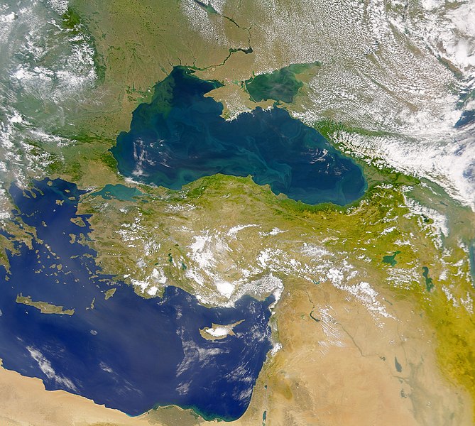
English: This cloud-free Sea-viewing Wide Field-of-view Sensor (SeaWiFS) view of the Black Sea reveals the colourful interplay of currents on the lake’s surface. The green crescent shaped pattern in the north-western corner of the Black Sea is due to the nutrient-rich, sediment-laden discharge of the Danube River stimulating biological activity. The brighter, more turquoise patterns on the lake to the south and east are probably blooms of another type of phytoplankton. |
| Ngit-khì | |
| Lòi-ngièn | NASA Earth Observatory |
| Chok-chá | The SeaWiFS Project |
Image courtesy of the NASA/Goddard Space Flight Center, and ORBIMAGE.
Su-khièn
| 本作品由NASA創作,屬於公有領域。根據NASA的版權政策:“NASA的創作除非另有聲明否則不受版權保護。”(參見:Template:PD-USGov/zh,NASA版權政策或JPL圖像使用政策) | ||
 |
警告:
|
Vùn-khien li̍t-sṳ́
Tiám-khim ngit-khì / sṳ̀-kiên lòi chhà-khon tông-sṳ̀ chhut-hien-ko ke vùn-khien.
| Ngit khì / Sṳ̀-kiên | Suk-lio̍k-thù | Vì-thu | Yung-fu | Yi-kien | |
|---|---|---|---|---|---|
| tông-chhièn | 2010年4月20日 (Ngi) 11:20 | | 2,080 × 1,865(1.07 MB) | Originalwana | {{Information |Description={{en|1=This cloud-free Sea-viewing Wide Field-of-view Sensor (SeaWiFS) view of the Black Sea reveals the colourful interplay of currents on the lake’s surface. The green crescent shaped pattern in the north-western cor |
Vùn-khien yung-chhú
Hâ poi ke 1-chak ya̍p-mien lièn-chiap to pún vùn-khien:
Chhiòn-vet tóng-on sṳ́-yung chhong-khóng
Hâ-lie̍t khì-thâ Wiki chûng sṳ́-yung liá-chak tóng on:
- ady.wikipedia.org ke sṳ́-yung chhong-khóng
- crh.wikipedia.org ke sṳ́-yung chhong-khóng
- en.wikipedia.org ke sṳ́-yung chhong-khóng
- eo.wikipedia.org ke sṳ́-yung chhong-khóng
- fr.wikipedia.org ke sṳ́-yung chhong-khóng
- gu.wikipedia.org ke sṳ́-yung chhong-khóng
- hr.wikipedia.org ke sṳ́-yung chhong-khóng
- hu.wikipedia.org ke sṳ́-yung chhong-khóng
- ilo.wikipedia.org ke sṳ́-yung chhong-khóng
- ja.wikipedia.org ke sṳ́-yung chhong-khóng
- kn.wikipedia.org ke sṳ́-yung chhong-khóng
- lg.wikipedia.org ke sṳ́-yung chhong-khóng
- pl.wikipedia.org ke sṳ́-yung chhong-khóng
- rm.wikipedia.org ke sṳ́-yung chhong-khóng
- sr.wikipedia.org ke sṳ́-yung chhong-khóng
- ta.wikipedia.org ke sṳ́-yung chhong-khóng
- uk.wikipedia.org ke sṳ́-yung chhong-khóng
- vi.wikipedia.org ke sṳ́-yung chhong-khóng
- wuu.wikipedia.org ke sṳ́-yung chhong-khóng
- zh.wikipedia.org ke sṳ́-yung chhong-khóng