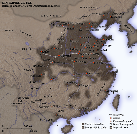
檔案:Qin empire 210 BCE.png
Qin_empire_210_BCE.png (555 × 545 chhiong-su, vùn-khien thai-séu: 567 KB, MIME lui-hîn: image/png)
Vùn-khien li̍t-sṳ́
Tiám-khim ngit-khì / sṳ̀-kiên lòi chhà-khon tông-sṳ̀ chhut-hien-ko ke vùn-khien.
| Ngit khì / Sṳ̀-kiên | Suk-lio̍k-thù | Vì-thu | Yung-fu | Yi-kien | |
|---|---|---|---|---|---|
| tông-chhièn | 2014年12月10日 (Sâm) 14:37 |  | 555 × 545(567 KB) | Nguyen1310 | Update to include ''Luo-Yue'' (Vi: ''Lạc Việt'') a member of the Baiyue (100 Yue) peoples, on the map in northern Vietnam. |
| 2006年11月21日 (Ngi) 14:08 |  | 555 × 545(540 KB) | Itsmine | == Commentary == As part of his unification of China in 221 BC, Qin Shi Huang divided his empire into thirty six commanderies, each subdivided into a number of counties. The significance of the administrative reforms was its in |
Vùn-khien yung-chhú
Hâ poi ke 1-chak ya̍p-mien lièn-chiap to pún vùn-khien:
Chhiòn-vet tóng-on sṳ́-yung chhong-khóng
Hâ-lie̍t khì-thâ Wiki chûng sṳ́-yung liá-chak tóng on:
- af.wikipedia.org ke sṳ́-yung chhong-khóng
- ar.wikipedia.org ke sṳ́-yung chhong-khóng
- ast.wikipedia.org ke sṳ́-yung chhong-khóng
- bg.wikipedia.org ke sṳ́-yung chhong-khóng
- bo.wikipedia.org ke sṳ́-yung chhong-khóng
- br.wikipedia.org ke sṳ́-yung chhong-khóng
- bxr.wikipedia.org ke sṳ́-yung chhong-khóng
- ca.wikipedia.org ke sṳ́-yung chhong-khóng
- cdo.wikipedia.org ke sṳ́-yung chhong-khóng
- cs.wikipedia.org ke sṳ́-yung chhong-khóng
- cv.wikipedia.org ke sṳ́-yung chhong-khóng
- cy.wikipedia.org ke sṳ́-yung chhong-khóng
- da.wikipedia.org ke sṳ́-yung chhong-khóng
- de.wikipedia.org ke sṳ́-yung chhong-khóng
- en.wikipedia.org ke sṳ́-yung chhong-khóng
- es.wikipedia.org ke sṳ́-yung chhong-khóng
- eu.wikipedia.org ke sṳ́-yung chhong-khóng
- fa.wikipedia.org ke sṳ́-yung chhong-khóng
- fr.wikipedia.org ke sṳ́-yung chhong-khóng
- ga.wikipedia.org ke sṳ́-yung chhong-khóng
- gl.wikipedia.org ke sṳ́-yung chhong-khóng
- he.wikipedia.org ke sṳ́-yung chhong-khóng
- hi.wikipedia.org ke sṳ́-yung chhong-khóng
- hr.wikipedia.org ke sṳ́-yung chhong-khóng
- id.wikipedia.org ke sṳ́-yung chhong-khóng
- incubator.wikimedia.org ke sṳ́-yung chhong-khóng
- jv.wikipedia.org ke sṳ́-yung chhong-khóng
- ka.wikipedia.org ke sṳ́-yung chhong-khóng
Kiám-sṳ liá vùn-khien ke kiên-tô chhiòn-vet sṳ́-yung chhong-khóng.


