檔案:NorthSeaCurrents.png
Yi-lám thai séu: 458 × 599 chhiong-su. Khì-thâ kié-sak-thu: 183 × 240 chhiong-su | 367 × 480 chhiong-su | 587 × 768 chhiong-su | 783 × 1,024 chhiong-su | 1,300 × 1,700 chhiong-su.
Ngièn-pún tóng-on (1,300 × 1,700 chhiong-su, vùn-khien thai-séu: 3.43 MB, MIME lui-hîn: image/png)
Vùn-khien sot-mìn
| Mèu-sut |
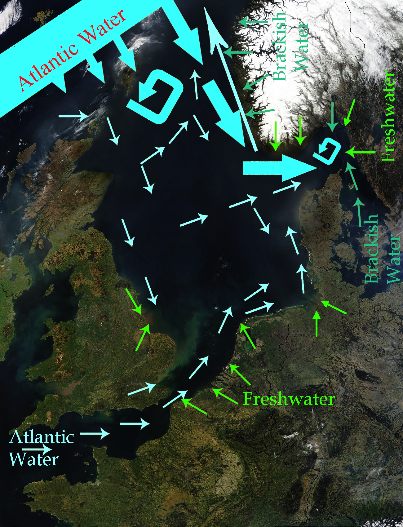
English: North Sea Map derived from NASA satellite image. This image depicts the currents in the North Sea. The intensive light blue broad arrows show the current and amount of flow from the Atlantic Ocean entering the northern area of the North Sea The smaller pale yellow arrows represent the current from the Atlantic Ocean entering through the English Channel. The bluish green arrows represent brackish water from fjords and the Baltic Sea. The green arrows represent freshwater from various rivers which drain land areas and discharge into the North Sea. Sources used to base this map upon were Safety at Sea currents and North Sea physiography (depth distribution and main currents) Guide to the Oceans By John Pernetta page 184 It would be nice to re-do this map with wiggly flowing arrows for the water currents. |
| Ngit-khì | 2009-01-22, recoloured in 2014-04-27 |
| Lòi-ngièn | Derivative work from File:NASA NorthSea1 2.jpg |
| Chok-chá | SriMesh, recoloured by Ulamm (talk) 22:29, 27 April 2014 (UTC) |
| 其他版本 |
• File:North-Sea-Labels.jpg • NorthSeaCurrents,jpg, the original presentation of the currents |
Su-khièn
我,本作品的著作權持有者,決定用以下授權條款發佈本作品:
此檔案採用創用CC 姓名標示-相同方式分享 3.0 未在地化版本授權條款。
- Ngì cho-tet chhṳ-yù:
- fûn-hióng – fu̍k-chṳ, fat-pu lâu chhòn-pô pún chok-phín
- chhùng-sîn siû-kói – chhóng-chok yên-yi̍t chok-phín
- 惟需遵照下列條件:
- 姓名標示 – 您必須指名出正確的製作者,和提供授權條款的連結,以及表示是否有對內容上做出變更。您可以用任何合理的方式來行動,但不得以任何方式表明授權條款是對您許可或是由您所使用。
- siông-thùng fông-sṳt fûn-hióng – 如果您利用本素材進行再混合、轉換或創作,您必須基於如同原先的相同或兼容的條款,來分布您的貢獻成品。

|
已授權您依據自由軟體基金會發行的無固定段落、封面文字和封底文字GNU自由文件授權條款1.2版或任意後續版本,對本檔進行複製、傳播和/或修改。該協議的副本列在GNU自由文件授權條款中。 |
Ngì cho-tet sién-chet Ngì sî-yeu ke su-khièn thiàu-khóan.
Vùn-khien li̍t-sṳ́
Tiám-khim ngit-khì / sṳ̀-kiên lòi chhà-khon tông-sṳ̀ chhut-hien-ko ke vùn-khien.
| Ngit khì / Sṳ̀-kiên | Suk-lio̍k-thù | Vì-thu | Yung-fu | Yi-kien | |
|---|---|---|---|---|---|
| tông-chhièn | 2014年4月27日 (Ngit) 22:56 | | 1,300 × 1,700(3.43 MB) | Ulamm | once more |
| 2014年4月27日 (Ngit) 22:48 |  | 1,300 × 1,700(3.47 MB) | Ulamm | more freshwater arrows | |
| 2014年4月27日 (Ngit) 22:29 |  | 1,300 × 1,700(3.47 MB) | Ulamm | == {{int:filedesc}} == {{Information |Description={{en|1=''North Sea Map'' derived from NASA satellite image. This image depicts the currents in the North Sea. The dark yellow broad arrows show the current and amount of flow from the Atlantic Ocean en... |
Vùn-khien yung-chhú
Hâ poi ke 1-chak ya̍p-mien lièn-chiap to pún vùn-khien:
Chhiòn-vet tóng-on sṳ́-yung chhong-khóng
Hâ-lie̍t khì-thâ Wiki chûng sṳ́-yung liá-chak tóng on:
- azb.wikipedia.org ke sṳ́-yung chhong-khóng
- ca.wikipedia.org ke sṳ́-yung chhong-khóng
- cs.wikipedia.org ke sṳ́-yung chhong-khóng
- cy.wikipedia.org ke sṳ́-yung chhong-khóng
- en.wikipedia.org ke sṳ́-yung chhong-khóng
- es.wikipedia.org ke sṳ́-yung chhong-khóng
- fi.wikipedia.org ke sṳ́-yung chhong-khóng
- hr.wikipedia.org ke sṳ́-yung chhong-khóng
- vi.wikipedia.org ke sṳ́-yung chhong-khóng