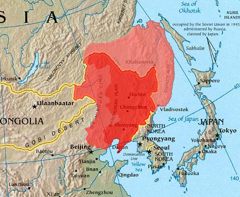
檔案:Manchuria.png
Manchuria.png (480 × 395 chhiong-su, vùn-khien thai-séu: 440 KB, MIME lui-hîn: image/png)
Vùn-khien li̍t-sṳ́
Tiám-khim ngit-khì / sṳ̀-kiên lòi chhà-khon tông-sṳ̀ chhut-hien-ko ke vùn-khien.
| Ngit khì / Sṳ̀-kiên | Suk-lio̍k-thù | Vì-thu | Yung-fu | Yi-kien | |
|---|---|---|---|---|---|
| tông-chhièn | 2023年12月21日 (Si) 09:32 |  | 480 × 395(440 KB) | Kwamikagami | Reverted to version as of 12:53, 21 March 2005 (UTC) -- last good version. Urup is not claimed by Japan. |
| 2023年5月27日 (Liuk) 15:26 |  | 480 × 395(443 KB) | Minchuchui | Reverted to version as of 11:36, 19 February 2020 (UTC) | |
| 2020年2月22日 (Liuk) 11:26 |  | 480 × 395(447 KB) | Wwbread | Reverted to version as of 20:27, 11 April 2019 (UTC) | |
| 2020年2月19日 (Sâm) 11:36 |  | 480 × 395(443 KB) | Императоры России | Reverted to version as of 16:48, 19 September 2019 (UTC) | |
| 2020年2月9日 (Ngit) 18:47 |  | 480 × 395(447 KB) | Wwbread | Reverted to version as of 20:27, 11 April 2019 (UTC). See discussion page. | |
| 2019年9月19日 (Si) 16:48 |  | 480 × 395(443 KB) | Императоры России | Kuye/Sakharin Island (库页岛) isn't included in Manchuria. | |
| 2019年9月13日 (Ńg) 03:54 |  | 480 × 395(447 KB) | Spodnikel | Reverted to version as of 20:27, 11 April 2019 (UTC) | |
| 2019年9月4日 (Sâm) 12:14 |  | 480 × 395(443 KB) | Императоры России | Reverted to version as of 12:30, 10 July 2018 (UTC) | |
| 2019年4月11日 (Si) 20:27 |  | 480 × 395(447 KB) | Wwbread | Kuye/Sakharin Island (库页岛) is a part of outer Manchuria. | |
| 2018年7月10日 (Ngi) 12:30 |  | 480 × 395(443 KB) | Trecătorul răcit | Contrast |
Vùn-khien yung-chhú
Mò ya̍p-mien lièn-chiap to pún vùn-khien.
Chhiòn-vet tóng-on sṳ́-yung chhong-khóng
Hâ-lie̍t khì-thâ Wiki chûng sṳ́-yung liá-chak tóng on:
- als.wikipedia.org ke sṳ́-yung chhong-khóng
- ar.wikipedia.org ke sṳ́-yung chhong-khóng
- arz.wikipedia.org ke sṳ́-yung chhong-khóng
- ast.wikipedia.org ke sṳ́-yung chhong-khóng
- azb.wikipedia.org ke sṳ́-yung chhong-khóng
- az.wikipedia.org ke sṳ́-yung chhong-khóng
- be-tarask.wikipedia.org ke sṳ́-yung chhong-khóng
- be.wikipedia.org ke sṳ́-yung chhong-khóng
- bg.wikipedia.org ke sṳ́-yung chhong-khóng
- bn.wikipedia.org ke sṳ́-yung chhong-khóng
- br.wikipedia.org ke sṳ́-yung chhong-khóng
- ca.wikipedia.org ke sṳ́-yung chhong-khóng
- cs.wikipedia.org ke sṳ́-yung chhong-khóng
- de.wikipedia.org ke sṳ́-yung chhong-khóng
- dsb.wikipedia.org ke sṳ́-yung chhong-khóng
- el.wikipedia.org ke sṳ́-yung chhong-khóng
- el.wikiversity.org ke sṳ́-yung chhong-khóng
- en.wikipedia.org ke sṳ́-yung chhong-khóng
- en.wikiversity.org ke sṳ́-yung chhong-khóng
- eo.wikipedia.org ke sṳ́-yung chhong-khóng
- es.wikipedia.org ke sṳ́-yung chhong-khóng
- eu.wikipedia.org ke sṳ́-yung chhong-khóng
- fa.wikipedia.org ke sṳ́-yung chhong-khóng
- frr.wikipedia.org ke sṳ́-yung chhong-khóng
- fr.wikipedia.org ke sṳ́-yung chhong-khóng
- ga.wikipedia.org ke sṳ́-yung chhong-khóng
- gl.wikipedia.org ke sṳ́-yung chhong-khóng
- he.wikipedia.org ke sṳ́-yung chhong-khóng
- hi.wikipedia.org ke sṳ́-yung chhong-khóng
- hu.wikipedia.org ke sṳ́-yung chhong-khóng
Kiám-sṳ liá vùn-khien ke kiên-tô chhiòn-vet sṳ́-yung chhong-khóng.


