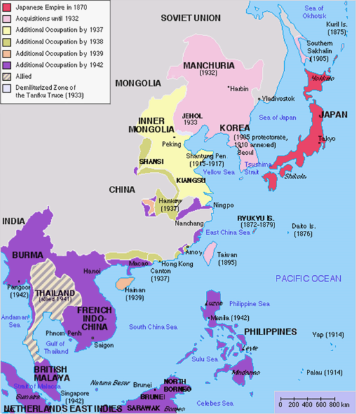
檔案:Japanese Empire2.png

Yi-lám thai séu: 515 × 599 chhiong-su. Khì-thâ kié-sak-thu: 206 × 240 chhiong-su | 412 × 480 chhiong-su | 660 × 768 chhiong-su | 1,032 × 1,201 chhiong-su.
Ngièn-pún tóng-on (1,032 × 1,201 chhiong-su, vùn-khien thai-séu: 927 KB, MIME lui-hîn: image/png)
Vùn-khien li̍t-sṳ́
Tiám-khim ngit-khì / sṳ̀-kiên lòi chhà-khon tông-sṳ̀ chhut-hien-ko ke vùn-khien.
| Ngit khì / Sṳ̀-kiên | Suk-lio̍k-thù | Vì-thu | Yung-fu | Yi-kien | |
|---|---|---|---|---|---|
| tông-chhièn | 2023年3月3日 (Ńg) 12:26 |  | 1,032 × 1,201(927 KB) | Hohum | Brighten |
| 2023年3月3日 (Ńg) 12:24 |  | 1,032 × 1,201(944 KB) | Hohum | less garish colours | |
| 2023年1月10日 (Ngi) 03:53 |  | 1,032 × 1,201(1,020 KB) | Artanisen | Added allied color. Thailand was in a coerced alliance (1941) thus part of the empire | |
| 2022年6月22日 (Sâm) 06:20 |  | 1,032 × 1,201(683 KB) | Crab2814 | Removed Tongking- France gave Japan military access to that region in 1940, not an occupational right. Fixed Sakhalin and Hainan. Removed Thailand, which was allied not occupied by Japan. | |
| 2020年8月3日 (Yit) 11:58 |  | 1,437 × 1,201(1.8 MB) | Artanisen | Bigger size and sharper version of the same map. The rest is the same. | |
| 2007年7月5日 (Si) 11:47 |  | 707 × 591(32 KB) | Mahahahaneapneap | pngcrushed | |
| 2007年5月27日 (Ngit) 01:31 |  | 707 × 591(48 KB) | Gryffindor | {{svg}} {{GFDL}} Modified version of Image:Japanese_Empire.png. Fixed Ryukyu Islands, Sichuan, grammar in table. Category:Maps of the history of Japan Category:Maps of the history of Korea Category:Maps of the history of Vietnam [[Categ | |
| 2007年2月27日 (Ngi) 15:13 |  | 508 × 591(36 KB) | Cristan | Optimized using PNGOUT | |
| 2005年12月22日 (Si) 11:24 |  | 508 × 591(47 KB) | Markalexander100 | {{GFDL}} Modified version of Image:Japanese_Empire.png. Fixed Ryukyu Islands, Sichuan, grammar in table. |
Vùn-khien yung-chhú
Hâ poi ke 1-chak ya̍p-mien lièn-chiap to pún vùn-khien:
Chhiòn-vet tóng-on sṳ́-yung chhong-khóng
Hâ-lie̍t khì-thâ Wiki chûng sṳ́-yung liá-chak tóng on:
- af.wikipedia.org ke sṳ́-yung chhong-khóng
- ar.wikipedia.org ke sṳ́-yung chhong-khóng
- ca.wikipedia.org ke sṳ́-yung chhong-khóng
- cs.wikipedia.org ke sṳ́-yung chhong-khóng
- de.wikipedia.org ke sṳ́-yung chhong-khóng
- en.wikipedia.org ke sṳ́-yung chhong-khóng
- eu.wikipedia.org ke sṳ́-yung chhong-khóng
- fa.wikipedia.org ke sṳ́-yung chhong-khóng
- fi.wikipedia.org ke sṳ́-yung chhong-khóng
- fr.wikipedia.org ke sṳ́-yung chhong-khóng
- gl.wikipedia.org ke sṳ́-yung chhong-khóng
- he.wikipedia.org ke sṳ́-yung chhong-khóng
- hy.wikipedia.org ke sṳ́-yung chhong-khóng
- it.wikipedia.org ke sṳ́-yung chhong-khóng
- ja.wikipedia.org ke sṳ́-yung chhong-khóng
- min.wikipedia.org ke sṳ́-yung chhong-khóng
- mk.wikipedia.org ke sṳ́-yung chhong-khóng
- ms.wikipedia.org ke sṳ́-yung chhong-khóng
- nl.wikipedia.org ke sṳ́-yung chhong-khóng
- oc.wikipedia.org ke sṳ́-yung chhong-khóng
- pam.wikipedia.org ke sṳ́-yung chhong-khóng
- pt.wikipedia.org ke sṳ́-yung chhong-khóng
- ro.wikipedia.org ke sṳ́-yung chhong-khóng
- ru.wikipedia.org ke sṳ́-yung chhong-khóng
Kiám-sṳ liá vùn-khien ke kiên-tô chhiòn-vet sṳ́-yung chhong-khóng.

