檔案:Average precipitation in the lower 48 states of the USA.png

Yi-lám thai séu: 800 × 538 chhiong-su. Khì-thâ kié-sak-thu: 320 × 215 chhiong-su | 640 × 430 chhiong-su | 1,024 × 689 chhiong-su | 1,280 × 861 chhiong-su | 2,785 × 1,873 chhiong-su.
Ngièn-pún tóng-on (2,785 × 1,873 chhiong-su, vùn-khien thai-séu: 2.19 MB, MIME lui-hîn: image/png)
Vùn-khien sot-mìn
| Mèu-sut |
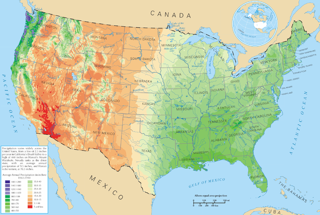
English: Average precipitation in the lower 48 states of the United States of America.
Español: Promedio de la precipitación de los 48 estados contiguos |
| Lòi-ngièn | https://nationalmap.gov/small_scale/printable/climatemap.html |
| Chok-chá | 美國內政部 |
Su-khièn
本地圖取自美國國家地圖集的某個版本。國家地圖集的絕大多數作品是美國聯邦政府的作品,因此屬於公有領域。
連結網址︰ NationalAtlas.gov | 1970年印刷版︰ 國會檔案館, Perry-Castañeda圖書館
|
Vùn-khien li̍t-sṳ́
Tiám-khim ngit-khì / sṳ̀-kiên lòi chhà-khon tông-sṳ̀ chhut-hien-ko ke vùn-khien.
| Ngit khì / Sṳ̀-kiên | Suk-lio̍k-thù | Vì-thu | Yung-fu | Yi-kien | |
|---|---|---|---|---|---|
| tông-chhièn | 2006年3月28日 (Ngi) 21:08 | | 2,785 × 1,873(2.19 MB) | Tom | ==Description== Average precipitation in the lower 48 states of the United States of America. ==License== {{PD-USGov-Atlas}} |
Vùn-khien yung-chhú
Hâ poi ke 2-chak ya̍p-mien lièn-chiap to pún vùn-khien:
Chhiòn-vet tóng-on sṳ́-yung chhong-khóng
Hâ-lie̍t khì-thâ Wiki chûng sṳ́-yung liá-chak tóng on:
- bg.wikipedia.org ke sṳ́-yung chhong-khóng
- cs.wikipedia.org ke sṳ́-yung chhong-khóng
- da.wikipedia.org ke sṳ́-yung chhong-khóng
- de.wikipedia.org ke sṳ́-yung chhong-khóng
- en.wikipedia.org ke sṳ́-yung chhong-khóng
- fr.wikipedia.org ke sṳ́-yung chhong-khóng
- he.wikipedia.org ke sṳ́-yung chhong-khóng
- ht.wikipedia.org ke sṳ́-yung chhong-khóng
- hu.wikipedia.org ke sṳ́-yung chhong-khóng
- hy.wikipedia.org ke sṳ́-yung chhong-khóng
- id.wikipedia.org ke sṳ́-yung chhong-khóng
- ja.wikipedia.org ke sṳ́-yung chhong-khóng
- lg.wikipedia.org ke sṳ́-yung chhong-khóng
- mg.wikipedia.org ke sṳ́-yung chhong-khóng
- pcd.wikipedia.org ke sṳ́-yung chhong-khóng
- pl.wikipedia.org ke sṳ́-yung chhong-khóng
- pl.wiktionary.org ke sṳ́-yung chhong-khóng
- Stany Zjednoczone
- Съединени щати
- Съединени американски щати
- Bandaríkin
- Bandaríki Norður-Ameríku
- Amerikan yhdysvallat
- Amerikka
- United States of America
- United States
- U.S.A.
- U.S.
- Stany Zjednoczone Ameryki
- Egyesült Államok
- Amerikai Egyesült Államok
- الولايات المتحدة
- Злучаныя Штаты Амерыкі
- fenua Marite
- ᐊᒥᐊᓕᑲ
- Amerikas förenta stater
- الولايات المتحدة الأمريكية
- Amerika Birləşmiş Ştatları
- Ameriketako Estatu Batuak
- Mokuʻāina-hui-ʻia
- АҚШ
- ئامېرىكا قوشما شتاتلىرى
Kiám-sṳ liá vùn-khien ke kiên-tô chhiòn-vet sṳ́-yung chhong-khóng.