檔案:Waterways New York City Map Julius Schorzman.png
Yi-lám thai séu: 616 × 600 chhiong-su. Khì-thâ kié-sak-thu: 247 × 240 chhiong-su | 493 × 480 chhiong-su | 789 × 768 chhiong-su | 1,052 × 1,024 chhiong-su | 2,104 × 2,048 chhiong-su | 2,652 × 2,582 chhiong-su.
Ngièn-pún tóng-on (2,652 × 2,582 chhiong-su, vùn-khien thai-séu: 1.88 MB, MIME lui-hîn: image/png)
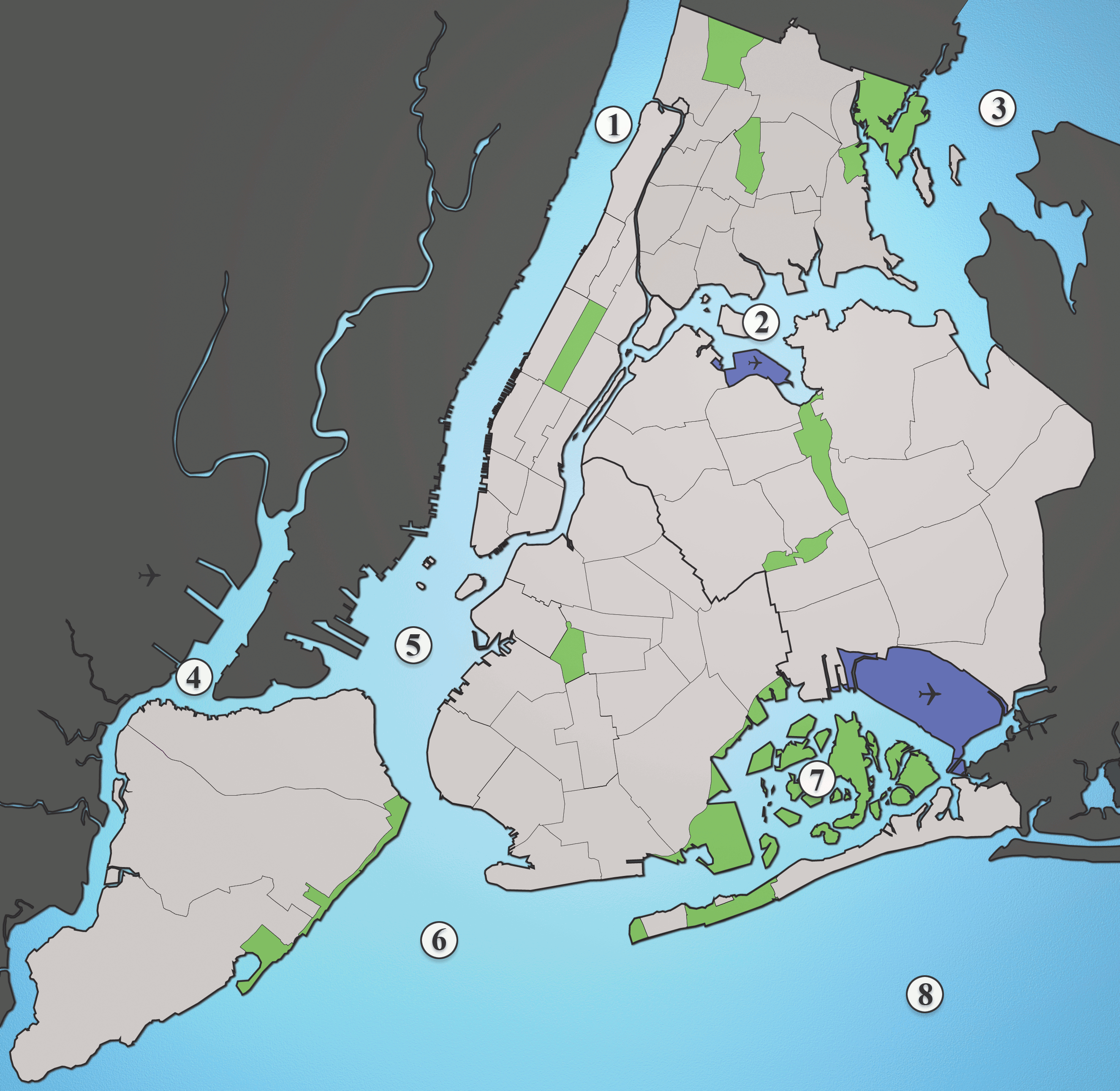
A map showing the major waterways in New York City.
- Hudson River
- East River
- Long Island Sound
- Newark Bay
- Upper New York Bay
- Lower New York Bay
- Jamaica Bay
- Atlantic Ocean
Source: I created this image myself using various maps and images as source material. (Please include the Spuyten Duvil)
此檔案採用創用CC 姓名標示-相同方式分享 2.5 通用版授權條款。
- Ngì cho-tet chhṳ-yù:
- fûn-hióng – fu̍k-chṳ, fat-pu lâu chhòn-pô pún chok-phín
- chhùng-sîn siû-kói – chhóng-chok yên-yi̍t chok-phín
- 惟需遵照下列條件:
- 姓名標示 – 您必須指名出正確的製作者,和提供授權條款的連結,以及表示是否有對內容上做出變更。您可以用任何合理的方式來行動,但不得以任何方式表明授權條款是對您許可或是由您所使用。
- siông-thùng fông-sṳt fûn-hióng – 如果您利用本素材進行再混合、轉換或創作,您必須基於如同原先的相同或兼容的條款,來分布您的貢獻成品。
Vùn-khien li̍t-sṳ́
Tiám-khim ngit-khì / sṳ̀-kiên lòi chhà-khon tông-sṳ̀ chhut-hien-ko ke vùn-khien.
| Ngit khì / Sṳ̀-kiên | Suk-lio̍k-thù | Vì-thu | Yung-fu | Yi-kien | |
|---|---|---|---|---|---|
| tông-chhièn | 2013年9月30日 (Yit) 21:01 | | 2,652 × 2,582(1.88 MB) | JohnnyMrNinja | Indexed colors, removed unused alpha channel and increased file compression |
| 2005年8月19日 (Ńg) 02:36 |  | 2,652 × 2,582(6.19 MB) | Quasipalm | A map showing the major waterways in New York City. 1) Hudson River 2) East River 3) Long Island Sound 4) Newark Bay 5) Upper New York Bay 6) Lower New York Bay 7) Jamaica Bay 8) Atlantic Ocean Source: I created this image using various maps and images. |
Vùn-khien yung-chhú
Hâ poi ke 1-chak ya̍p-mien lièn-chiap to pún vùn-khien:
Chhiòn-vet tóng-on sṳ́-yung chhong-khóng
Hâ-lie̍t khì-thâ Wiki chûng sṳ́-yung liá-chak tóng on:
- af.wikipedia.org ke sṳ́-yung chhong-khóng
- ar.wikipedia.org ke sṳ́-yung chhong-khóng
- be.wikipedia.org ke sṳ́-yung chhong-khóng
- ca.wikipedia.org ke sṳ́-yung chhong-khóng
- cs.wikipedia.org ke sṳ́-yung chhong-khóng
- da.wikipedia.org ke sṳ́-yung chhong-khóng
- de.wikipedia.org ke sṳ́-yung chhong-khóng
- en.wikipedia.org ke sṳ́-yung chhong-khóng
- eo.wikipedia.org ke sṳ́-yung chhong-khóng
- es.wikipedia.org ke sṳ́-yung chhong-khóng
- eu.wikipedia.org ke sṳ́-yung chhong-khóng
- frr.wikipedia.org ke sṳ́-yung chhong-khóng
- fr.wikipedia.org ke sṳ́-yung chhong-khóng
- he.wikipedia.org ke sṳ́-yung chhong-khóng
- id.wikipedia.org ke sṳ́-yung chhong-khóng
- it.wikipedia.org ke sṳ́-yung chhong-khóng
Kiám-sṳ liá vùn-khien ke kiên-tô chhiòn-vet sṳ́-yung chhong-khóng.