檔案:Derbyshire UK locator map 2010.svg

此 SVG 檔案的 PNG 預覽的大小:494 × 600 chhiong-su。 Khì-thâ kié-sak-thu: 198 × 240 chhiong-su | 395 × 480 chhiong-su | 633 × 768 chhiong-su | 843 × 1,024 chhiong-su | 1,687 × 2,048 chhiong-su | 1,108 × 1,345 chhiong-su.
Ngièn-pún tóng-on (SVG文件,尺寸:1,108×1,345像素,文件大細:302 KB)
Vùn-khien sot-mìn
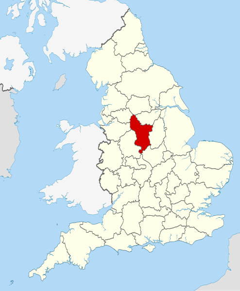
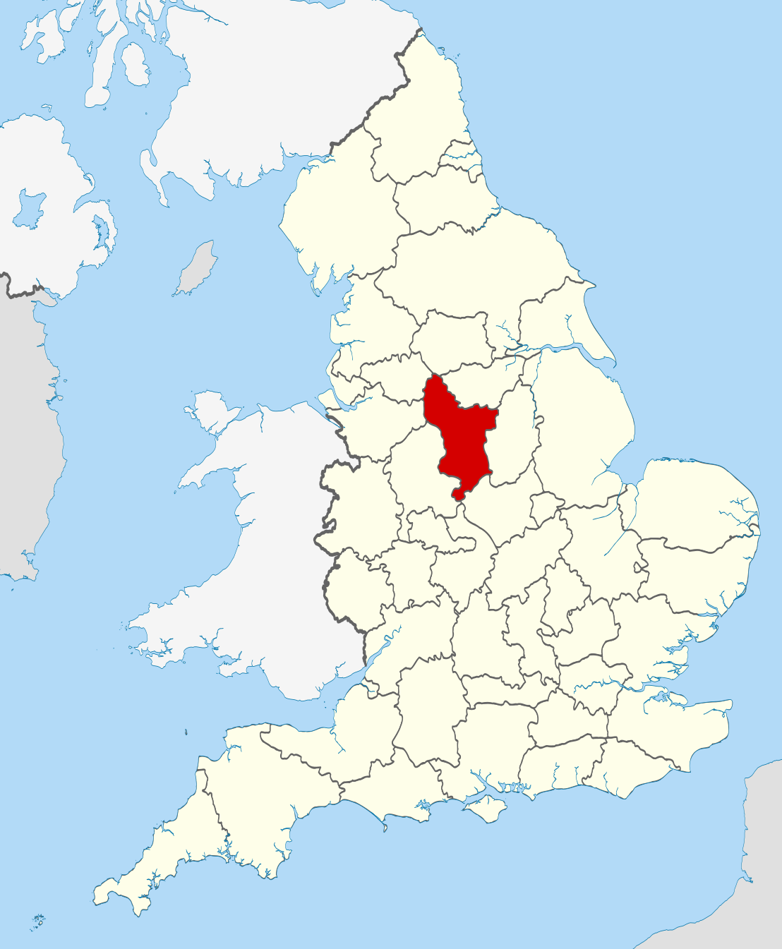
| Mèu-sut | Location of the ceremonial county of Derbyshire within England. |
| Ngit-khì | |
| Lòi-ngièn |
National Geospatial-Intelligence Agency
|
| Chok-chá | Nilfanion |
Su-khièn
我,本作品的著作權持有者,決定用以下授權條款發佈本作品:
此檔案採用創用CC 姓名標示-相同方式分享 3.0 未在地化版本授權條款。
- Ngì cho-tet chhṳ-yù:
- fûn-hióng – fu̍k-chṳ, fat-pu lâu chhòn-pô pún chok-phín
- chhùng-sîn siû-kói – chhóng-chok yên-yi̍t chok-phín
- 惟需遵照下列條件:
- 姓名標示 – 您必須指名出正確的製作者,和提供授權條款的連結,以及表示是否有對內容上做出變更。您可以用任何合理的方式來行動,但不得以任何方式表明授權條款是對您許可或是由您所使用。
- siông-thùng fông-sṳt fûn-hióng – 如果您利用本素材進行再混合、轉換或創作,您必須基於如同原先的相同或兼容的條款,來分布您的貢獻成品。

|
已授權您依據自由軟體基金會發行的無固定段落、封面文字和封底文字GNU自由文件授權條款1.2版或任意後續版本,對本檔進行複製、傳播和/或修改。該協議的副本列在GNU自由文件授權條款中。 |
Ngì cho-tet sién-chet Ngì sî-yeu ke su-khièn thiàu-khóan.

|
This is one of the images forming part of the Valued image set: Locator maps of the Ceremonial counties of England on Wikimedia Commons. The image set has been assessed under the valued image set criteria and is considered the most valued set on Commons within the scope:
Locator maps of the Ceremonial counties of England
You can see its nomination at Commons:Valued image candidates/Locator maps of English ceremonial counties. |
Vùn-khien li̍t-sṳ́
Tiám-khim ngit-khì / sṳ̀-kiên lòi chhà-khon tông-sṳ̀ chhut-hien-ko ke vùn-khien.
| Ngit khì / Sṳ̀-kiên | Suk-lio̍k-thù | Vì-thu | Yung-fu | Yi-kien | |
|---|---|---|---|---|---|
| tông-chhièn | 2010年11月23日 (Ngi) 22:33 | | 1,108 × 1,345(302 KB) | Nilfanion | == Summary == {{Information |Description=Location of the ceremonial county of Derbyshire within England. |Source=Ordnance Survey [https://www.ordnancesurvey.co.uk/opendatadownload/products.html OpenData]: *County bou |
Vùn-khien yung-chhú
Hâ poi ke 1-chak ya̍p-mien lièn-chiap to pún vùn-khien:
Chhiòn-vet tóng-on sṳ́-yung chhong-khóng
Hâ-lie̍t khì-thâ Wiki chûng sṳ́-yung liá-chak tóng on:
- af.wikipedia.org ke sṳ́-yung chhong-khóng
- an.wikipedia.org ke sṳ́-yung chhong-khóng
- ar.wikipedia.org ke sṳ́-yung chhong-khóng
- ast.wikipedia.org ke sṳ́-yung chhong-khóng
- be-tarask.wikipedia.org ke sṳ́-yung chhong-khóng
- be.wikipedia.org ke sṳ́-yung chhong-khóng
- bg.wikipedia.org ke sṳ́-yung chhong-khóng
- bn.wikipedia.org ke sṳ́-yung chhong-khóng
- br.wikipedia.org ke sṳ́-yung chhong-khóng
- ca.wikipedia.org ke sṳ́-yung chhong-khóng
- ceb.wikipedia.org ke sṳ́-yung chhong-khóng
- cs.wikipedia.org ke sṳ́-yung chhong-khóng
- dag.wikipedia.org ke sṳ́-yung chhong-khóng
- en.wikipedia.org ke sṳ́-yung chhong-khóng
- Derbyshire
- Thornhill, Derbyshire
- Newhaven, Derbyshire
- Howden Reservoir
- Longdendale Trail
- Leam, Derbyshire
- Tunstead Milton
- Hartshorne, Derbyshire
- Greenhill Lane
- Pilsbury
- River Amber
- Woodhead, Derbyshire
- Lose Hill
- Sparrowpit
- Egginton
- Pikehall
- Win Hill
- Blackwell, Bolsover
- Abbot's Chair
- Abney, Derbyshire
- Ible
- Rattle, Derbyshire
- Beeley
- Birch Vale
- Trent Lock
- Hopton, Derbyshire
- Kedleston
- Template:Derbyshire-geo-stub
- Rushop
- Litton, Derbyshire
- Unstone
- Ault Hucknall
- Butterley
- Abney and Abney Grange
- Aldercar and Langley Mill
- Alderwasley
Kiám-sṳ liá vùn-khien ke kiên-tô chhiòn-vet sṳ́-yung chhong-khóng.